Introduction
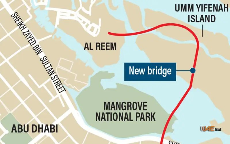
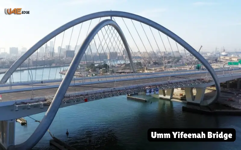
Umm Yifeenah Bridge, which is the first stage of the Mid-Island Parkway. The 11km-long corridor will connect Al Reem Island, Umm Yifenah Island and Sheikh Zayed bin Sultan Street and eventually constitute the hub of a network between Saadiyat Island, Al Raha Beach and Khalifa City.
Geographic and Urban Environment
Location
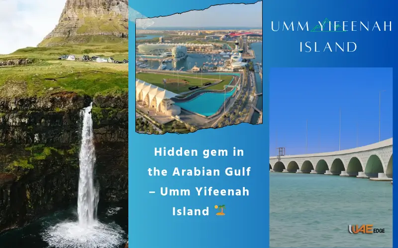
Umm Yifenah Island (or Umm Yifenah) is located on the north-eastern coast of the main island of Abu Dhabi. It is located between the developed Al Reem Island and the arterial Sheikh Zayed bin Sultan Street (E10). Its shoreline consists of mangroves, tidal flats and shallow waters- characteristic of the mid-islands of Abu Dhabi.
Connectivity
Al Reem Island is currently one of the most crowded residential and commercial centres in Abu Dhabi. The traffic between Al Reem and other cities is heavy daily. The bridges that existed were strained and journeys to the mainland had to be done with detours. The Mid-Island Parkway will offer direct routes of high capacity to reduce congestion, travel time, and unify the city islands into one city system.
Connectivity & Nearby Areas
| From | To | Distance / Feature |
| Al Reem Island | Umm Yifenah Island | Connected via bridge |
| Umm Yifenah Island | Sheikh Zayed bin Sultan Street | Direct highway link |
| Saadiyat Island | Al Reem Island | Future Parkway extension |
| Khalifa City | Al Raha Beach | Planned Parkway connection |
Umm Yifeenah Bridge Project
Key Specifications
Length: 11 km
Configuration: Three lanes per direction.
Capacity: 6,000 trips per hour in each direction (12,000 in total)
Bridges and Causeways
This stage consists of seven bridges, two of which are over-water bridges (3.8 km overall). Arch causeways are used to maintain tidal movement and marine traffic in the design. This is an essential method in the conservation of mangroves and the maintenance of natural hydrology.
Pedestrian and Cycle Facilities
The Umm Yifeenah Bridge is designed to include pedestrian paths, cycling lanes and a bike rental station as opposed to the ancient highways. The trip is also pleasant due to landscaped walkways and ocean and skyline vistas that are suitable both for recreation and commuting.
Stakeholders and Delivery
Public and Private Partners
Aldar Properties is the strategic partner of the project led by the Department of Municipalities and Transport (DMT). The government and a large developer formed a partnership that enabled the government to match the infrastructure with the development of nearby real estate.
Day by Day
His Highness Sheikh Khaled bin Mohamed bin Zayed Al Nahyan opened the bridge on 9 February 2023. Representatives of DMT and Aldar and other Abu Dhabi departments were present, which highlighted the significance of it being a city-shaping project.
Sustainability and environmental
The seventh sustainable development goal is to conserve sensitive habitats.
Mangroves and tidal flats in the Umm Yifeenah are critical for biodiversity in Abu Dhabi. The bridge incorporates arched causeways and spans that are well placed to ensure that they do not disrupt the water flow so that the marine life may move through.
Materials and Landscape
Approximately 85 percent of the construction materials were local and this eliminated transport emissions and helped industries in the UAE. The project also complements the planting of mangroves in the surrounding Jubail Island in order to reinforce coastal ecosystems. Planting along the walks and roads will provide shade and reduce heat, which will serve the interests of the users and the environment.
Commuter Information
| Route | Distance | Estimated Travel Time |
| Al Reem Island → Umm Yifeenah | ~2 km | 5–7 minutes |
| Umm Yifeenah → Sheikh Zayed bin Sultan Street | ~8 km | 10–12 minutes |
| Umm Yifeenah → Saadiyat Island (Future) | ~5 km | 5–7 minutes |
| Al Reem → Khalifa City (Future) | ~20 km | 20–25 minutes |
Social, Mobility and Economic Effects
Cutting Travel Times
The people living in Al Reem Island and the adjacent areas have been given a direct connection to the Sheikh Zayed bin Sultan Street, which has reduced the commuting time by a significant margin and relieved the congestion on the older bridges.
Promoting Active Transport
Walking and cycling tracks and bike hire options mean non-motorised movement is more convenient, and in line with the global trend of healthier, low-carbon cities.
Property Values and Quality of Life
Less congestion results in decreased stress and emissions. The scenery infrastructure and the provision of new forms of transportation enhance the lifestyle of the residents and in most cases enhance the value of nearby property which promotes investment and mixed-use development.
Economic Stimulus
The benefits in the economy are local sourcing, construction employment and future maintenance. Businesses and investors also come to places that were not easily accessible before because of infrastructure upgrades.
Mid Island Parkway Vision
Phase 1: Umm Yifeenah Bridge
It is but the beginning of a very great network in this bridge. It defines the path on which subsequent stages will be based.
Future Phases
The Parkway is intended to connect Al Reem Island, Saadiyat Island, Al Raha Beach and Khalifa City, as well as increasing walking and cycling paths, landscaped greenways, interchanges and perhaps public transport connections by 2028. The final product will be an integrated mid-island spine comprising several districts.
Design
Overall, the engineering process confronts the challenge of navigating the sea, grounded in the functioning of natural forces and phenomena underpinned by the natural environment.
Elements and Logistics Precasting
The manufacture of concrete elements offsite sped up the construction process and enhanced quality control without causing a great amount of disturbance to the environment.
Safety and User Experience
There are barriers of safety, lighting and clear points of access to high-speed traffic lanes; pedestrian and cycling paths. Such a design contributes to active traveling being safe even in the presence of a large highway.
Timeline and Implementation
| Phase | Scope | Key Dates |
| Planning & Design | Feasibility | Pre-2022 |
| Phase 1 | 11 km superhighway, 7 bridges | Inaugurated Feb 2023 |
| Parkway | Links to Saadiyat, Al Raha Beach, Khalifa City | Completion by 2028 |
Potential Challenges
Congestion Shifts
New capacity is relieving pressure, but could encourage increased traffic and it might need further investment in public transport and demand control.
Maintenance Costs
Structures may suffer as a result of marine environments. Maintenance in the long-term budgets should include maintenance to maintain safety and performance.
Environmental Vigilance
The mitigation measures should be sustained in the long term such as the water flow, the sedimentation, and the protection of the habitat against human intrusion.
Accessibility of Non-Motorised Paths
This is a guarantee that pedestrians can access non-motorised paths.
It is also necessary to have safe, shaded and well-connected entry/exit points in case the walking and cycling facilities are to become what they can be.
Strategic Significance
Integrated Urban Growth
The Parkway is helping to create a balance in urban growth and development, enabling Abu Dhabi to create additional districts without congesting current roads by connecting previously separated islands.
Sustainability and Vision 2030
The bridge reflects the long-term vision of Abu Dhabi: diversified mobility, environmental conservation and the global standard of infrastructural development that will boost the well-being of residents.
Investment and Real Estate
Better connectivity increases investor confidence, drives mixed-use development and increases the appeal of more up-and-coming neighbourhoods.
Experiences
There are other UAE and international examples of such trends:
- The bridge of Hudayriat Island in Abu Dhabi is also a combination of road and recreation with nature conservation.
- The interchanges in the city of Dubai show that the development of new areas can be unlocked by well-organised road networks.
- The water-bridges of Northern Europe show how causeways can strike a compromise between engineering requirements and natural flows and dynamic mobility.
Opportunities Ahead
- Having public transport (buses or light rail in the future) integrated into the Parkway.
- Green areas, mangrove walkways and observation decks to increase recreation.
- Smart technology, which monitors traffic and the environment.
- Making sure that there is social equity so that every community may enjoy enhanced access.
Conclusion
The Umm Yifeenah Bridge is not only an 11-kilometer highway. It is the transition by Abu Dhabi to a connected, sustainable and people-oriented city. The emirate is establishing a new standard of infrastructure by connecting Al Reem Island with Sheikh Zayed bin Sultan Street on the Umm Yifenah Island with a high-capacity road and walking and cycling tracks, and by incorporating environmental protection and sourcing locally. With the continued stages of the Mid-Island Parkway being implemented through to 2028, the benefits to the residents and tourists will be that people can now travel faster, have a bigger variety of recreational experiences and have a more urbanised city space.
Must Visit: Sharjah Clock Tower Representative Marque of the UAE
Al Hudaiba Awards Hub in Dubai What to Expect Before You Go
FAQs
1. Where is Umm Yifenah Island?
Umm Yifenah Island, in Abu Dhabi, is between the mainland and Al Reem Island. It is well accessible through the new bridge and is included in the increasing network of islands of the city.
2. What is the Umm Yifeenah Bridge?
The bridge is an 11km pathway linking Umm Yifenah Island to Al Reem Island and the mainland and has six car lanes and walking and cycling paths.
3. Is it possible to walk or cycle on the bridge as a visitor?
Yes! The bridge also has walking and cycling paths and is therefore ideal during a scenic walk or bike ride along with the view of the islands and coastline of Abu Dhabi.
4. What is the benefit of the bridge to Abu Dhabi traffic?
It gives commuters a more direct route that is faster, cuts traffic jams on older bridges and primary roads, and increases travel time throughout the city.
5. Is the project environmentally friendly?
Absolutely. The bridge incorporates designs to safeguard mangroves and tidal movement, combined with landscaping and local materials to have a significant impact on the environment.
6. When is the Mid-Island Parkway to be completed?
Phase 1 was opened in 2023 and the whole Parkway, connecting multiple islands is planned to be finished by 2028, providing even more convenient communication lines and more picturesque routes.