Overview of Khorfakkan Road
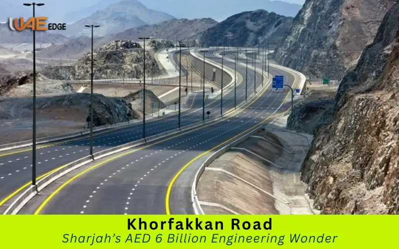
Khorfakkan Road (also known as Sharjah-Khorfakkan Highway) is one of the UAE’s most impressive engineering achievements. This world-class highway, which runs through the Hajar Mountains and connects Sharjah on the west to Khorfakkan in the east within 45 minutes, is one of the UAE’s greatest engineering and infrastructure achievements.
This highway, built under the vision of Sheikh Dr. Sultan bin Muhammad Al Qasimi (Ruler of Sharjah), not only links two cities but also symbolizes Sharjah’s commitment towards progress, sustainability, and connectivity.
Location
Khorfakkan Road crosses the Sharjah emirate, starting at Al Badee Interchange near Emirates Road E611, and continuing eastwards to Khorfakkan on the coast of the Gulf of Oman.
The highway, which covers a distance between 89 and 91 kilometers, cuts a straight path through mountainous terrain once thought to be nearly impossible.
Purpose of Vision
The journey to Khorfakkan used to take over 2 hours before the construction of this highway. This new highway reduces travel times by over half and promotes tourism, commerce, and social integration in Sharjah’s eastern and central regions.
Developer Cost
Under the direct supervision of the Sharjah Government, the Sharjah Roads and Transport Authority developed the project. It is one of the largest and most expensive infrastructure projects in the Emirate.
Construction Schedule
- Plan and Feasibility Studies for the Early 2000s
- Design and Engineering 2010-2014
- Construction phase: 2015 to 2019
- Official Inauguration: April 2019
Routes and Structures
Start and Finish Points
It begins at Al Badee Interchange and links to Emirates Road (E611) before ending at Khorfakkan Corniche near the waterfront. The route passes through a variety of landscapes, including plains, mountains, and valleys.
Major Route Segments
1. Sharjah Plains Section
The western part of the highway is flat and desert-like, with broad roads that have multiple lanes. It provides a smooth drive. This section is ideal for fast travel, and it connects to the other UAE highways.
2. Mountain Range Section
The Hajar Mountains are home to some of the UAE’s most breathtaking natural sights. The segment is characterized by tunnels, bridges, and inclines that traverse rugged terrain.
3. Coastal Descent Section
This final stretch winds its way down to Khorfakkan, providing panoramic views of the Arabian Sea. The drive changes from the Rocky Mountains of earlier to lush greenery with a sea breeze.
Technical Specifications
- Total Length: 89 km
- Lanes: 3 in each direction
- Maximum speed: 120 km/h, but this is subject to change in curves and tunnels.
- Smart lighting: LED with motion sensor
- Security: Emergency booths and Tunnel Ventilation Systems
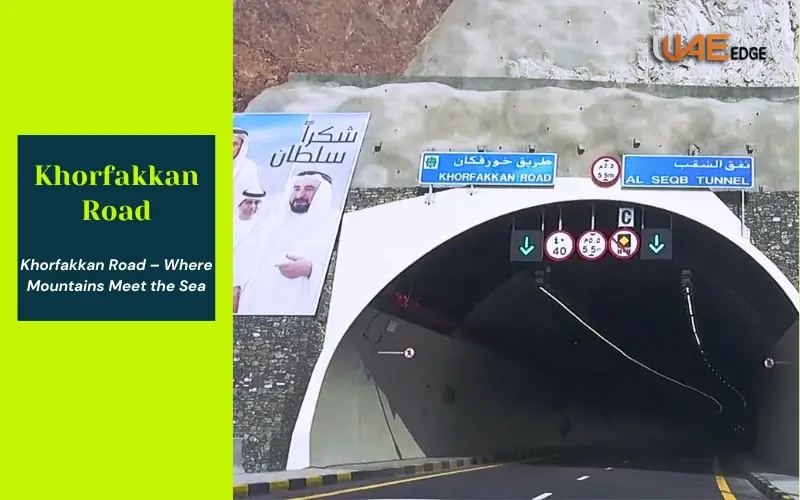
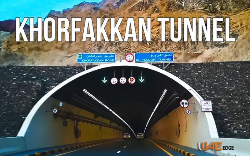
Heart of Khorfakkan Road – Tunnels
Tunnel System Overview
The highway is notable for its five mountain tunnels totaling more than 9 km in length. The tunnels on the Khorfakkan Road are not just a design masterpiece, but also an engineering triumph.
Major Tunnels
| Tunnel Name | Length | Highlights |
| Al Sidra Tunnel | 2.7 km | The longest mountain tunnel in the Middle East |
| Al Suhub Tunnel | 1,5 km | Al Suhub Rest Area is connected by this road |
| Al Ghail Tunnel | 1 km | Dual ventilation shafts are included in the design |
| Al Haray Tunnel | 800 m | Scenic tunnel near the Khorfakkan entrance |
| Al Juwair Tunnel | 3 km (combined smaller tunnels) | Central mountainous section links |
Related Blog: Sharjah Clock Tower Representative Marque of the UAE
Engineering Innovations
Construction Technology
The solid rock of the mountains was carved through using modern drilling and blasting techniques. Tunnels lined with reinforced cement and waterproofed to resist seasonal rain were equipped.
Safety and Monitoring
The tunnels are:
- Fire suppression systems with automatic fire suppression
- CCTV cameras
- Every 400 metres, there are emergency exits.
- Air Quality Monitoring Sensors
The tunnels are designed to meet international standards for safety.
Scenic and Tourist Appeal
Breathtaking Landscapes
Khorfakkan Road feels like a journey into a world of natural beauty. Hajar Mountains, with its rugged peaks, deep valleys, and dramatic scenery, is a stunning backdrop. It is fascinating to see the contrast between the rugged terrain of Oman and the turquoise water of the Gulf of Oman.
Rest Stops and Viewpoints
Al Rafisah Dam
Al Rafisah Dam, located midway on the route, is a peaceful mountain lake that’s surrounded by lush greenery and walking trails. Kayaking, boating, and cafes with views of the water are available to visitors.
Al Suhub Rest Area
Al Suhub Rest Area, perched high on a mountain ridge, offers panoramic views over Khorfakkan and its surrounding sea. The rest area has a seating area, a cafe, and an elevated platform that offers a panoramic view of the sea and Khorfakkan city.
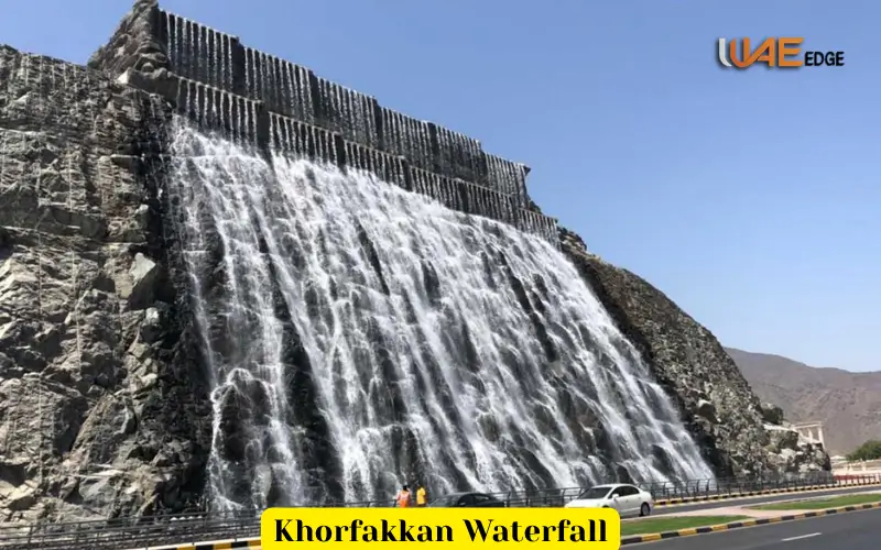
Khorfakkan Amphitheatre & Waterfall
The Khorfakkan Amphitheatre is located at the entrance to the city. It was inspired by Roman Architecture. A man-made waterfall cascades down the mountainside. The two landmarks come alive at night and create a stunning visual effect.
Economic and Social Importance
Trade and Logistics Boost
The Port of Khorfakkan, one of the UAE’s deepest natural port is located in Khorfakkan. This highway reduces travel costs and time by providing a direct link between the Port of Khorfakkan and Sharjah. Sharjah is a more attractive logistical hub because of this connectivity.
Tourism as a Driver of Economic Growth
Khorfakkan Road, since its opening in 2007, has had a significant impact on tourism. The number of weekend trips, adventure tours, and family vacations has increased. This in turn, has led to an increase in hotels and local businesses.
Social Benefits
The highway is a daily reality changer for residents
- Access to healthcare and education is easier.
- Travel between the coastal regions and the inland areas is now quicker.
- Enhance community interaction through cultural exchange.
Environmental and Safety Measures
Eco-Friendly Design
Sharjah’s government made sure that the project adhered with environmental standards.
- Minimum rock displacement – Only the essential excavations have been carried out.
- Installation of erosion control systems to protect the mountain slopes.
- Use native plants to landscape along roads and maintain an ecological balance.
Safety Feature
The modern infrastructure of Khorfakkan Road makes it one of the most safe roads in the UAE.
- Signage that adapts to the weather.
- In tunnels, reflective lane markers are used to improve visibility.
- Every few kilometers, there are emergency lay-bys.
- 24 hour surveillance via connected control centres
Infrastructure and Travel Facilities
Roadside Services
Rest stops are strategically placed along the route to ensure that it remains clean.
- Gas stations are located at the start and the end of routes.
- Al Rafisah Dam Rest Area and Al Suhub Rest Area have cafes, bathrooms, and mosques.
- Park in designated areas for photography and sightseeing.
Accessibility
All motorists are welcome to use the road, including cars, light trucks, and buses. Safety reasons restrict the use of heavy trucks during rush hours.
There are no tollgates, so everyone can enjoy free entry.
Smart and EV Integration
The future plans will include smart traffic sensors and electric vehicle chargers that make Sharjah a “smart” city.
Travel Tips: A Guide for Visitors
Travel at the Best Time
Khorfakkan Road looks best at sunrise or sunset, when the sun’s rays enhance the mountain scenery.The drive is particularly comfortable in the cooler months of October-April.
Photographing and sightseeing
- Please stop at the designated viewing platform.
- Al Rafisah Dam & Al Suhub Rest Area make for great panoramic photos.
- Drones must be approved by the authorities before they can be used.
Local Destinations
| Destination | Distances from Khorfakkan | Attractions |
| Fujairah | 25 km | Fujairah Fort, beaches, corniche |
| Kalba | 15 km | Mangrove forest, Kalba Lake, Corniche |
| Dibba | 40 km | Mountain trekking, diving, and traditional souks |
Future of Expansion and Development
Smart Upgrades
Sharjah plans to improve the digital infrastructure of its highway by integrating AI-based traffic monitoring and real-time updates. The proposal includes solar-powered charging stations for EVs and rest areas powered by EVs.
Tourist Expansion
Along the route are new eco-lodges, mountain trails and sustainable adventure opportunities.
Conclusion
Khorfakkan Road represents more than just a route of transportation — it is a trip through culture, nature and innovation.
It connects Sharjah’s city centre to the serene east coast of the country, enriching the economic experience and travel experiences for millions.
The Khorfakkan Road is a perfect blend of engineering and environmental excellence. Its record-breaking tunnels are a testament to Sharjah’s vision. This road is a testament to a country’s commitment to turning its vision into reality.
FAQs About Khorfakkan Road
What is Khorfakkan Road?
The Khorfakkan Road or Sharjah-Khorfakkan Highway is an 89 kilometer long road that connects Sharjah to Khorfakkan, on the East Coast, through the Hajar Mountains.
Khorfakkan Road was built by who?
The Sharjah Roads and Transport Authority developed it under H.H. Sheikh Dr. Sultan bin Muhammad Al Qasimi.
What is the driving distance between Sharjah and Khorfakkan?
It takes 45 minutes to travel, as opposed to two hours prior construction.
What makes this road unique?
The tunnels are five in number, with a high-tech engineering design and a spectacular view of the mountains, valleys and coast.
Does it cost anything to use the app?
Khorfakkan Road is free of tolls and charges.
Where are the best places to visit?
Al Rafisah Dam, Al Suhub Rest Area, Khorfakkan Waterfall, and Khorfakkan Amphitheatre are top attractions.
Are tourists safe?
Absolutely. To ensure the safety of motorists on this highway, there are CCTV cameras, LED lights, emergency exits and intelligent monitoring systems.
How far can I travel from Khorfakkan to visit other emirates?
Fujairah, and Kalba, are both within a few minutes’ drive, so it is ideal for an all-day tour of the coast.